Laos General Information
Lao People's Democratic Republic | |
| |
Motto: "Paix, indépendance, démocratie, unité et prospérité" (English: "Peace, independence, democracy, unity and prosperity") | |
Capital and largest city | |
Official languages | |
Recognised languages | |
Spoken languages | · Lao · Hmong · Khmu · French |
(2015[2]) | List of ethnicities[show] |
• Total | 237,955 km2 (91,875 sq mi) (82nd) |
• Water (%) | 2 |
• Estimate | 7,061,507 (103rd) |
• 2015 census | 6,492,228 |
• Density | 26.7/km2 (69.2/sq mi) (151st) |
Currency | |
Time zone | |
Date format | dmy |
right | |
Laos, officially the Lao People's Democratic Republic is a socialist state and the only landlocked country in Southeast Asia. At the heart of the Indochinese peninsula, Laos is bordered by Myanmar and China to the northwest, Vietnam to the east, Cambodia to the southeast and Thailand to the west and southwest.
Present Laos traces its historic and cultural identity to Lan Xang, which existed from the 14th century to the 18th century as one of the largest kingdoms in Southeast Asia. Due to its central geographical location in Southeast Asia, the kingdom became a hub for overland trade, and became wealthy economically and culturally. After a period of internal conflict, Lan Xang broke into three separate kingdoms—Luang Phrabang, Vientiane, and Champasak. In 1893, the three territories came under a French protectorate and were united to form what is now known as Laos. It briefly gained independence in 1945 after Japanese occupation, but was recolonised by France until it won autonomy in 1949. Laos became independent in 1953, with a constitutional monarchy under Sisavang Vong. A post-independence civil war began, which saw the communist resistance, supported by the Soviet Union, fight against the monarchy that later came under influence of military regimes supported by the United States. After the Vietnam War ended in 1975, the communist Pathet Lao came to power, ending the civil war. Laos was then dependent on military and economic aid from the Soviet Union until its dissolution in 1991.
In 2018, the country had the fourth highest GDP (PPP) per capita in Southeast Asia, after Singapore, Malaysia, and Thailand and country ranked 139th on the Human Development Index (HDI), indicating medium development. Laos is a member of the Asia-Pacific Trade Agreement, the ASEAN, East Asia Summit, and La Francophonie. Laos applied for membership of the World Trade Organization in 1997; on 2 February 2013, it was granted full membership. It is a one-party socialist republic, espousing Marxism–Leninism governed by the Lao People's Revolutionary Party, under which non-governmental organizations have routinely characterized the country's human rights record as poor, citing repeated abuses such as torture, restrictions on civil liberties, and persecution of minorities.
Geography
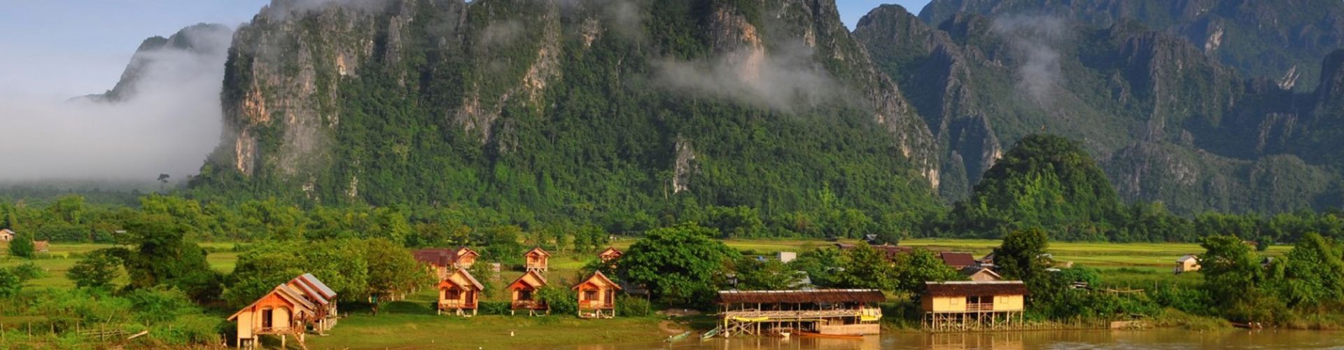
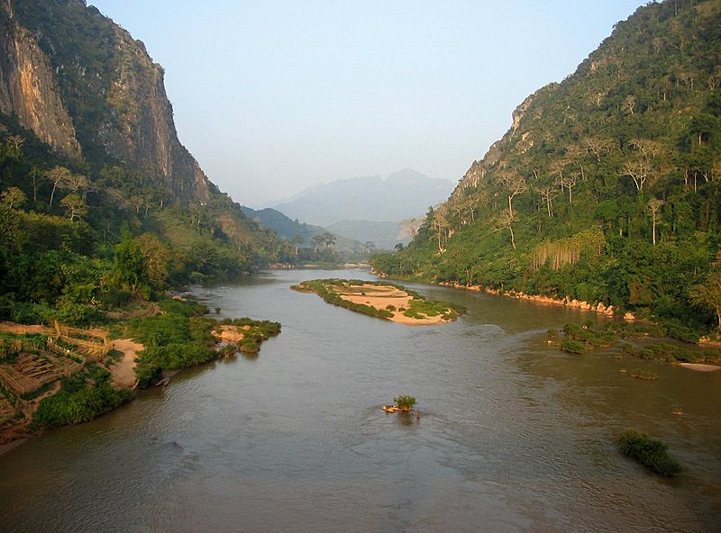
Laos is the only landlocked country in Southeast Asia, and it lies mostly between latitudes 14° and 23°N (a small area is south of 14°), and longitudes 100° and 108°E. Its thickly forested landscape consists mostly of rugged mountains, the highest of which is Phou Bia at 2,818 metres (9,245 ft), with some plains and plateaus. The Mekong River forms a large part of the western boundary with Thailand, where the mountains of the Annamite Range form most of the eastern border with Vietnam and the Luang Prabang Range the northwestern border with the Thai highlands. There are two plateaux, the Xiangkhoang in the north and the Bolaven Plateau at the southern end. The climate is tropical and influenced by the monsoon pattern.
There is a distinct rainy season from May to November, followed by a dry season from December to April. Local tradition holds that there are three seasons (rainy, cold and hot) as the latter two months of the climatologically defined dry season are noticeably hotter than the earlier four months. The capital and largest city of Laos is Vientiane and other major cities include Luang Prabang, Savannakhet, and Pakse.
In 1993 the Laos government set aside 21 percent of the nation's land area for habitat conservation preservation. The country is one of four in the opium poppy growing region known as the "Golden Triangle". According to the October 2007 UNODC fact book Opium Poppy Cultivation in South East Asia, the poppy cultivation area was 15 square kilometres (5.8 sq mi), down from 18 square kilometres (6.9 sq mi) in 2006.
Laos can be considered to consist of three geographical areas: north, central, and south.
Climate
Most of the year is hot and humid. Laos enjoys a tropical climate with two distinct seasons. The rainy season is from the beginning of May to the end of September, and the dry season is from October through April. The yearly average temperature is about 28 degrees Celsius, rising to a maximum of 38 degrees Celsius during April and May.

In Vientiane a minimum temperature of 19 degrees Celsius is to be expected during January. In mountainous areas, however, temperature drops to as low as 14-15 degrees Celsius during the winter months, and during cold nights, can easily reach the freezing point. The average precipitation is highest in Southern Laos, where the Annamite Mountains receive over 3,000 mm. annually. In Vientiane rainfall is about 1,500-2,000 mm., and in the Northern provinces only 1,000-1,500 mm.
When to go
The best time for visiting most of Laos is between November and February, when it rains the least and is not too hot. It’s also Laos’s main season for both national and regional bun (festivals).
If you plan to focus on the mountainous northern provinces, the hot season (from March to May) and early rainy season (around June) is not bad either, as temperatures are moderate at higher elevations. Southern Laos, on the other hand, is best avoided from March to May, when day-time temperatures break into the 40s and nights aren’t much cooler.
The rainy season is not as bad as you might think. While it will rain – very heavily – the downpours are often fairly brief and can be bracketed by long periods of sunshine. The rains also clear dust from the skies and land, making everything clearer and brighter. Of course, there are downsides; unsealed roads can become quagmires and extensive travel in remote areas like Salavan, Phongsali and Sainyabuli might be impossible. River travel can be a good alternative during these months. If you intend to travel extensively by river, November is the best; flooding has usually subsided yet river levels are still high enough for maximum navigability. Between January and June, low water can make navigating some rivers difficult.
December to February and August are the peak tourist times. January, in particular, is very busy and booking ahead is advisable.
Administrative divisions
Laos is divided into 17 provinces (khoueng) and one prefecture (kampheng nakhon), which includes the capital city Vientiane (Nakhon Louang Viangchan). A new province, Xaisomboun Province, was established on 13 December 2013. Provinces are further divided into districts (muang) and then villages (ban). An "urban" village is essentially a town.
An updated map of Lao provinces (from 2014) | |||||||||||||||||||||||||||||||||||||||||||||||||||||||||||||||||||||||||||||||||||||||||||||||||
| |||||||||||||||||||||||||||||||||||||||||||||||||||||||||||||||||||||||||||||||||||||||||||||||||
Tourism
The tourism sector has grown rapidly, from 80,000 international visitors in 1990, to 1.876 million in 2010. Tourism is expected to contribute US$679.1 million to the gross national product in 2010, rising to US$1.5857 billion by 2020. In 2010, one in every 10.9 jobs was in the tourism sector. Export earnings from international visitors and tourism goods are expected to generate 15.5 percent of total exports or US$270.3 million in 2010, growing in nominal terms to US$484.2 million (12.5 percent of the total) in 2020.
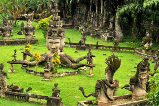
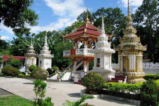
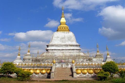
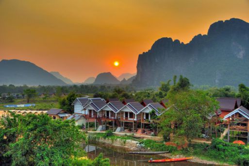
The official tourism slogan is "Simply Beautiful". The main attractions for tourists include Buddhist culture and colonial architecture in Luang Prabang; gastronomy and ancient temples in the capital of Vientiane; backpacking in Muang Ngoi Neua and Vang Vieng; ancient and modern culture and history in the Plain of Jars region (main article: Phonsavan); Laos Civil War history in Sam Neua; trekking and visiting hill tribes in a number of areas including Phongsaly and Luang Namtha; spotting tigers and other wildlife in Nam Et-Phou Louey; caves and waterfalls near Thakhek; relaxation, the Irrawaddy dolphin and Khone Phapheng Falls at Si Phan Don or, as they are known in English, the Four Thousand Islands; Vat Phou, an ancient Khmer temple complex; and the Bolaven Plateau for waterfalls and coffee. The European Council on Trade and Tourism awarded the country the "World Best Tourist Destination" designation for 2013 for this combination of architecture and history.
Luang Prabang and Vat Phou are both UNESCO World Heritage sites, with the Plain of Jars expected to join them once more work to clear Unexploded ordnance has been completed.[citation needed] Major festivals include Lao New Year celebrated around 13–15 April and involves a water festival similar but more subdued than that of Thailand and other Southeast Asian countries.
The Lao National Tourism Administration, related government agencies and the private sector are working together to realise the vision put forth in the country's National Ecotourism Strategy and Action Plan. This includes decreasing the environmental and cultural impact of tourism; increasing awareness in the importance of ethnic groups and biological diversity; providing a source of income to conserve, sustain and manage the Lao protected area network and cultural heritage sites; and emphasizing the need for tourism zoning and management plans for sites that will be developed as ecotourism destinations.
Laos is known for silk and local handicraft products, which are on display in Luang Prabang's night market, among other places. Another specialty is mulberry tea.
Infrastructure
The main international airports are Vientiane's Wattay International Airport and Luang Prabang International Airport with Pakse International Airport also having a few international flights. The national carrier is Lao Airlines. Other carriers serving the country include Bangkok Airways, Vietnam Airlines, AirAsia, Thai Airways International, China Eastern Airlines and Silk Air.
Much of Laos lacks adequate infrastructure. Laos has no railways, except a short link to connect Vientiane with Thailand over the Thai–Lao Friendship Bridge. A short portage railway, the Don Det–Don Khon narrow gauge railway was built by the French in Don Det and Don Khon in Champasak Province but has been closed since the 1940s. In the late 1920s, work began on the Thakhek–Tan Ap railway that would have run between Thakhek, Khammouane Province and Tân Ấp Railway Station, Quảng Bình Province, Vietnam through the Mụ Giạ Pass. The scheme was aborted in the 1930s. The major roads connecting the major urban centres, in particular Route 13, have been significantly upgraded in recent years, but villages far from major roads can be reached only through unpaved roads that may not be accessible year-round.
There is limited external and internal telecommunication, but mobile phones have become widespread in urban centres. In many rural areas electricity is at least partly available. Songthaews (pick-up trucks with benches) are used in the country for long-distance and local public transport.
Laos has made particularly noteworthy progress increasing access to sanitation and has already met its 2015 Millennium Development Goal (MDG) target. Laos's predominantly rural (68 percent, source: Department of Statistics, Ministry of Planning and Investment, 2009) population makes investing in sanitation difficult. In 1990 only eight percent of the rural population had access to improved sanitation. Access rose rapidly from 10 percent in 1995 to 38 percent in 2008. Between 1995 and 2008 approximately 1,232,900 more people had access to improved sanitation in rural areas.
Laos's progress is notable in comparison to similar developing countries. This success is in part due to small-scale independent providers emerging in a spontaneous manner or having been promoted by public authorities. The authorities in Laos have recently developed an innovative regulatory framework for Public–Private partnership contracts signed with small enterprises, in parallel with more conventional regulation of State-owned water enterprises.
Ethnicity
The people of Laos are often categorised by their distribution by elevation: (lowlands, midlands and upper high lands) as this somewhat correlates with ethnic groupings.
Lao Loum (lowland people)
More than half of the nation's population is ethnic Lao—the principal lowland inhabitants, and the politically and culturally dominant people of Laos. The Lao belong to the Tai linguistic group who began migrating south from China in the first millennium CE. Ten percent belong to other "lowland" groups, which together with the Lao people make up the Lao Loum.
Lao Theung (midland people)
In the central and southern mountains, Mon-Khmer-speaking groups, known as Lao Theung or mid-slope Laotians, predominate. Other terms are Khmu, Khamu (Kammu) or Kha as the Lao Loum refer to them to indicate their Austroasiatic language affiliation. However, the latter is considered pejorative, meaning 'slave'. They were the indigenous inhabitants of northern Laos. Some Vietnamese, Laotian Chinese and Thai minorities remain, particularly in the towns, but many left after independence in the late 1940s, many of whom relocated either to Vietnam, Hong Kong, or to France. Lao Theung constitute about 30 percent of the population.
Lao Soung (highland people)
Hill people and minority cultures of Laos such as the Hmong, Yao (Mien) (Hmong-Mien), Dao, Shan, and several Tibeto-Burman speaking peoples have lived in isolated regions of Laos for many years. Mountain/hill tribes of mixed ethno/cultural-linguistic heritage are found in northern Laos, which include the Lua and Khmu people who are indigenous to Laos. Collectively, they are known as Lao Soung or highland Laotians. Lao Soung account for only about 10 percent of the population.
Languages
The official and majority language is Lao, a language of the Tai-Kadai language family. However, only slightly more than half of the population speaks Lao natively. The remainder, particularly in rural areas, speak ethnic minority languages. The Lao alphabet, which evolved sometime between the 13th and 14th centuries, was derived from the ancient Khmer script and is very similar to Thai, and easily understood by readers of Thai script. Languages like Khmu (Austroasiatic) and Hmong (Hmong-Mien) are spoken by minorities, particularly in the midland and highland areas. A number of Laotian sign languages are used in areas with high rates of congenital deafness.
French is still commonly used in government and commerce and over a third of Laos's students are educated through the medium of French with French being compulsory for all other students. Throughout the country signage is bilingual in Lao and French, with French being predominant. English, the language of the Association of Southeast Asian Nations (ASEAN), has become increasingly studied in recent years. It is also a member of the French organisation La Francophonie.
Religion
Sixty-six percent of Laotians were Theravada Buddhist, 1.5 percent Christian, 0.1 percent Muslim, 0.1 Jewish percent, and 32.3 percent were other or traditional (mostly practitioners of Satsana Phi) in 2010. Buddhism has long been one of the most important social forces in Laos. Theravada Buddhism has coexisted peacefully since its introduction to the country with the local polytheism.
Culture
Theravada Buddhism is a dominant influence in Lao culture. It is reflected throughout the country from language to the temple and in art, literature, performing arts, etc. Many elements of Lao culture predate Buddhism, however. For example, Laotian music is dominated by its national instrument, the khaen, a type of bamboo pipe that has prehistoric origins. The khaen traditionally accompanied the singer in lam, the dominant style of folk music. Among the lam styles, the lam saravane is probably the most popular.
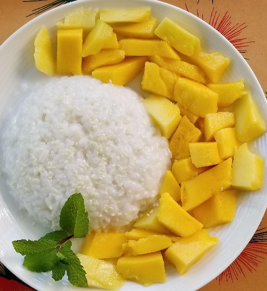
Sticky rice is a characteristic staple food and has cultural and religious significance to the Lao people. Sticky rice is generally preferred over jasmine rice, and sticky rice cultivation and production is thought to have originated in Laos. There are many traditions and rituals associated with rice production in different environments and among many ethnic groups. For example, Khammu farmers in Luang Prabang plant the rice variety Khao Kam in small quantities near the hut in memory of dead parents, or at the edge of the rice field to indicate that parents are still alive.
Sinh is a traditional garment worn by Laotian women in daily life. It is a hand-woven silk skirt that can identify the woman who wears it in a variety of ways. In particular, it can indicate which region the wearer is from.
Cuisine
Lao cuisine or Laotian cuisine is the cuisine of Laos, which is distinct from other Southeast Asian cuisines.
The staple food of the Lao is steamed sticky rice. In the Lao language, sticky rice is known as khao niao: khao means 'rice', and niao means 'sticky'. In fact, the Lao eat more sticky rice than any other people in the world. Sticky rice is considered the essence of what it means to be Lao. It is a common belief within the Lao community that no matter where they are in the world, sticky rice will always be the glue that holds the Lao communities together, connecting them to their culture and to Laos. Often the Lao will refer to themselves as luk khao niaow, which can be translated as 'children or descendants of sticky rice'.
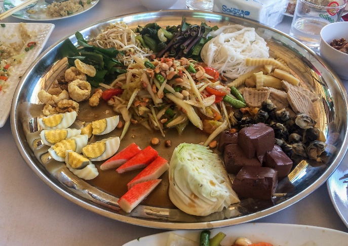
The trifecta of Laos' national cuisine are sticky rice, larb, and tam mak hoong. The most famous Lao dish is larb; sometimes also spelled laab or laap), a spicy mixture of marinated meat or fish that is sometimes raw (prepared like ceviche) with a variable combination of herbs, greens, and spices. Another Lao invention is a spicy green papaya salad dish known as tam mak hoong, more famously known to the West as som tam.
Lao cuisine has many regional variations, corresponding in part to the fresh foods local to each region. A French legacy is still evident in the capital city, Vientiane, where baguettes are sold on the street and French restaurants are common and popular, which were first introduced when Laos was a part of French Indochina.