Kon Tum Overview
The remote Kon Tum province is located in the northernmost region of Vietnam’s Central Highland. It shares the common border with Laos, Cambodia on the west, with Quang Nam province on the North, Quang Ngai province on the east and Gia Lai province on the south. 50% of the province’s area is forest with valuable species of plants and birds.
Topography
The common topographical features of Kon Tum are of the highland type. This province is west of the Truong Son Mountain range, slopping from north to south and from east to west. The terrain is very steep in the north, with the height in this area varying from 800–1,200m, and the height on the southern side is from 500–530m. Ngoc Linh Mountain is the highest of the province at 2,600m.
Climate
Kontum has feature climate of Central Highland. That is tropical monsoon one. The temperature, with a range of 20–24oC, is lowest in January and the highest in April and May. The difference between the lowest and highest is a mere 6–7oC. The rainy season is from April to October and the dry season is from November to March.
Tourism
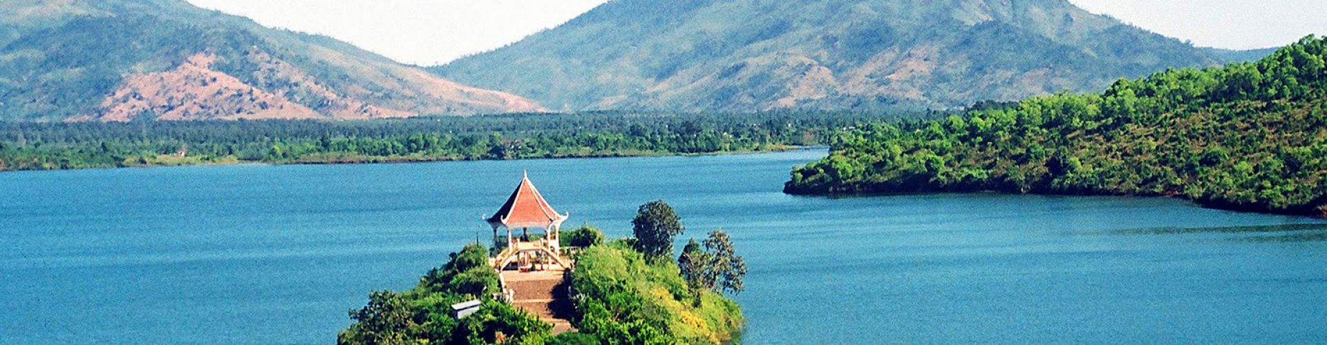
Compared to other provinces such as Lam Dong (with Dalat), Kon Tum attracts relatively few travelers since it is quite mountainous. Its provincial capital is Kon Tum town, which is situated on the bank of Dakbla River. Kon Tum is featured with the majestic mountainous landscape and several tourist attractions such as Ngok Linh Mountain, Chu Mon Ray Primitive Forest, Dak Tre Tourist Site, and Dak To Ho Spring. Besides, there are historical relics namely Kontum Former Prison, Dak Glei Prison, Ho Chi Minh Trail, Dak To, Tan Canh Battle Field. Coming to Kon Tum, many tourists are impressed by the wooden stilt houses in Ba Na village and Communal House (Nha Rong), which can be found nowhere else. Kontum has colorful, diversified culture of ethnic groups. Their customs are unique with special traditional festivals like cong chieng (gongs), buffalo stabling, leaving- the- tomb, new rice festivals. Among them, cong chieng culture is pride of Central Highlands’ People because it was recognized as a Masterpiece of the Oral and Intangible Cultural Heritage of Humanity (November 25, 2005) by UNESCO. Gongs and gong culture present a means to affirm the community and its cultural identities. The cultural space of Tay Nguyen gong spreads over five provinces, including Kon Tum, Gia Lai, Dak Lak, Dak Nong and Lam Dong and the masters of gong culture are the ethnic groups, including Ba Na, Xe Dang, M’nong, Ede and Gia Rai. One special festival can be found in Kontum is Village Land Praying Ceremony (end of the 2nd and beginning of the 3rd lunar month). This is a festival of the Ba Na people who live in Kontum and Gia Lai. Ba Na villagers hold the Village Land Praying Ceremony in preparation for the new crop or moving to new land. Before the days of establishing the new village, Ba Na people held a two-day ceremony. They prayed to their deities in hope that they would be given favorable working conditions and to inform the deities about the work in the upcoming year.
Transportation
Kontum is 246km from Buon Ma Thuot, 215km from Quy Nhon, 49km from Pleiku. National Highway No.14 runs from west of Quang Nam, vie Kontum Town, then to Gia Lai, Dak Lak, Ho Chi Minh City. National Highway No.24 connects Kontum to Quang Ngai.


.png "Travel Tips")