World heritage in Myanmar
To receive a UNESCO listing is a great honour and reflection of the rich heritage and culture of Myanmar. UNESCO includes in its lists cultural and natural sites of extraordinary importance that need to be safeguarded for the benefit of present and future generations. A number of sites in Myanmar are part of the UNESCO […]
To receive a UNESCO listing is a great honour and reflection of the rich heritage and culture of Myanmar. UNESCO includes in its lists cultural and natural sites of extraordinary importance that need to be safeguarded for the benefit of present and future generations. A number of sites in Myanmar are part of the UNESCO listings.UNESCO provides the World Heritage designation to cultural and natural sites that are of invaluable importance to humanity and need to be protected for the sake of future generations. At present, Myanmar has 2 sites included in this list – Bagan, added in 2019, and Pyu Ancient Cities, included in 2014.
Bagan
 Myanmar
- N21 8 56 E94 53 4
- Date of Inscription: 2019
- Criteria: (iii)(iv)(vi)
- Property : 5,005.49 ha
- Buffer zone: 18,146.83 ha
- Ref: 1588
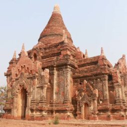
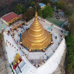
Lying on a bend of the Ayeyarwady River in the central plain of Myanmar, Bagan is a sacred landscape, featuring an exceptional range of Buddhist art and architecture. The seven components of the serial property include numerous temples, stupas, monasteries and places of pilgrimage, as well as archaeological remains, frescoes and sculptures. The property bears spectacular testimony to the peak of Bagan civilization (11th -13th centuries CE), when the site was the capital of a regional empire. This ensemble of monumental architecture reflects the strength of religious devotion of an early Buddhist empire.
Outstanding Universal Value
Brief synthesis
Bagan is a sacred landscape which features an exceptional array of Buddhist art and architecture, demonstrates centuries of the cultural tradition of the Theravada Buddhist practice of merit making (Kammatic Buddhism), and provides dramatic evidence of the Bagan Period (Bagan Period 11th – 13th centuries), when redistributional Buddhism became a mechanism of political control, with the king effectively acting as the chief donor. During this period, the Bagan civilisation gained control of the river transport, extending its influence over a large area. The traditions of merit making resulted in a rapid increase in temple construction, peaking in the 13th century. The serial property of eight components is located on a bend in the Ayeyarwady River, in the central dry zone of Myanmar. Seven of the components are located on one side of the River, and one (component 8) is located on the opposite side. Intangible attributes of the property are reflected in Buddhist worship and merit-making activities, traditional cultural practices and farming. The serial property of eight components consists of 3,595 recorded monuments – including stupas, temples and other structures for Buddhist spiritual practice, extensive archaeological resources, and many inscriptions, murals and sculptures. Bagan is a complex, layered cultural landscape which also incorporates living communities and contemporary urban areas.
Criterion (iii): Bagan is an exceptional and continuing testimony to the Buddhist cultural tradition of merit making, and to the peak of Bagan civilisation in the 11th-13th centuries when it was the capital of a regional empire.
Criterion (iv): Bagan contains an extraordinary ensemble of Buddhist monumental architecture, reflecting the strength of religious devotion of an early major Buddhist empire. Within the context of the rich expressions and traditions of Buddhist architecture and art found throughout Asia, Bagan is distinctive and outstanding.
Criterion (vi): Bagan is an exceptional example of the living Buddhist beliefs and traditions of merit making, expressed through the remarkable number of surviving stupas, temples and monasteries, supported by continuing religious traditions and activities. While the evidence of practices of merit-making are common in many Buddhist sites and areas, the influences established in the Bagan period, and the scale and diversity of expressions, and continuing traditions make Bagan exceptional.
————————–
Pyu Ancient Cities
 Myanmar
- N22 28 12 E95 49 7
- Date of Inscription: 2014
- Criteria: (ii)(iii)(iv)
- Property : 5,809 ha
- Buffer zone: 6,790 ha
- Ref: 1444
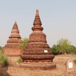
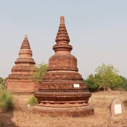
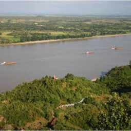
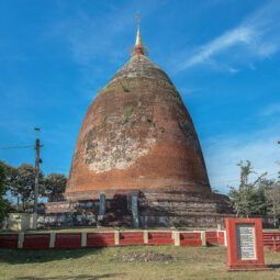
Pyu Ancient Cities includes the remains of three brick, walled and moated cities of Halin, Beikthano and Sri Ksetra located in vast irrigated landscapes in the dry zone of the Ayeyarwady (Irrawaddy) River basin. They reflect the Pyu Kingdoms that flourished for over 1,000 years between 200 BC and AD 900. The three cities are partly excavated archaeological sites. Remains include excavated palace citadels, burial grounds and manufacture sites, as well as monumental brick Buddhist stupas, partly standing walls and water management features – some still in use – that underpinned the organized intensive agriculture.
Outstanding Universal Value
Brief Synthesis
The Pyu Ancient Cities provide the earliest testimony of the introduction of Buddhism into Southeast Asia almost two thousand years ago and the attendant economic, socio-political and cultural transformations which resulted in the rise of the first, largest, and longest-lived urbanized settlements of the region up until the 9th century. The Pyu showed a striking capacity to assimilate Indic influences and swiftly move into a significant degree of re-invention. They created a special form of urbanization, the city of extended urban format, which subsequently influenced urbanization in most of mainland Southeast Asia. These earliest Buddhist city-states played a seminal role in the process of transmitting the literary, architectural and ritual traditions of Pali-based Buddhism to other societies in the sub-region where they continue to be practiced up to the present.
Halin, Beikthano and Sri Ksetra together as a Serial Property jointly testify to the several aspects of the development of this new model of urban settlement for the Southeast Asian region. Together the three cities provide evidence for the entire sequence and range of Pyu urban transformation from ca. 2nd century BCE to the 9th century CE, Buddhist monastic communities, distinctive mortuary practice, skilful water management, and long distant trade. At all three Pyu Ancient City sites, the irrigated landscape of the Pyu era is still impacting on the rural livelihoods of the modern population, while the religious monuments continue to be venerated by Buddhist pilgrims from throughout the region.
Criterion (ii): Due to interaction between indigenous Pyu societies with Indic cultures from the 2nd century BCE, Buddhism achieved its first permanent foothold in Southeast Asia among the Pyu cities, where it was embraced by all classes of society from the ruling elite to agrarian labourers. Marked by imposing memorial stupas and other sophisticated forms of brick ritual structures, the Pyu Ancient Cities provide the earliest evidence of the emergence of these innovative architectural forms in the region, some of which have no known prototypes. The development of Pyu Buddhist urban culture had widespread and enduring impact throughout Southeast Asia, providing stimulus for later state formation after the 5th century CE following the onward transmission of Buddhist teaching and monastic practice into other parts of mainland Southeast Asia.
Criterion (iii): The Pyu Ancient Cities marked the emergence of the first historically-documented Buddhist urban civilization in Southeast Asia. The establishment of literate Buddhist monastic communities arose in tandem with the re-organization of agricultural production, based on expert management of seasonally-scarce water resources and the specialized production of manufactured goods in terracotta, iron, gold, silver and semi-precious stones both for veneration and for trade. Buddhism underpinned the construction of religious monuments in brick through royal and common public patronage, marked by the shift to permanent materials from earlier timber building techniques. The Pyu developed unique mortuary practices using burial urns to store cremated remains in communal funerary structures. Trading networks linked the Pyu ancient cities with commercial centres in Southeast Asia, China and India. Through this network Buddhist missionaries carried their Pali-based teaching into other areas of mainland Southeast Asia.
Criterion (iv): Technological innovations in resource management, agriculture and manufacturing of brick and iron at the Pyu Ancient Cities created the preconditions leading to significant advances in urban planning and building construction. These innovations resulted in the rise of the three earliest, largest, and most long-lived Buddhist urban settlements in all of Southeast Asia. The Pyu cities’ urban morphology set a new template of extended urban format characterized by massive gated walls surrounded by moats; a network of roads and canals linking urban space within the walls with extensive areas of extramural development, containing civic amenities, monumental religious structures defined by towering stupas and sacred water bodies. At or near the centre of each ancient city was an administrative compound containing the palace marking the cosmic hub of the Pyu political and social universe.
=======================
Beikthano
Beikthano (also known as Panhtwa city) situated in the irrigated Magway Region, near present-day Taungdwingyi. In the era of the Pyu city-states it was a city of considerable significance, possibly a local capital replacing Sri Ksetra. Today the modest village is noted for its hot springs and archaeological sites. Beikthano, Hanlin, and Sri Ksetra, the ancient cities of the Pyu Kingdom were built on the irrigated fields of the dry zone of the Ayeyawady River basin. They were inscribed by UNESCO on its List of World Heritage Sites in Southeast Asia in May 2014 for their archaeological heritage traced back more than 1,000 years to between 200 BC and 900 AD.
Beikthano with direct land access to the well-watered Kyaukse plains to its northeast, is the oldest urban site so far discovered and scientifically excavated site. Its remains—the structures, pottery, artefacts, and human skeletons—date from 200 BCE to 100 CE. Named after the Hindu god Vishnu, the city may be the first capital of a culturally and perhaps even politically uniform state in the history of Burma. It was a large fortified settlement, measuring approximately 300 hectares inside the rectangular (3 km by 1 km) walls. The walls and fortifications along it measured six meters thick, and are radiocarbon dated to a period between 180 BCE and 610 CE. Like most subsequent cities, the main entrance of the walls led to the palace, which faced east. Stupas and monastic buildings have also been excavated within the city walls.
Location
Beikthano is located 12 miles west of Taungdwingyi Township. Magway Region on the Taungdwingyi-Magway Highway. Its co-ordinates are latitude (20°) North and (95° / 23’) East and is built on ground 450 feet above sea level. The ancient city of Beikthano covered an area of 3.3 square miles. The eastern city wall was 10.000 feet in length. the northern wall was 9.000 feet. the southern wall was 8.000 feet. while the western wall has collapsed owing to soil erosion caused by the action of the Yanpè Creek. Beikthano was defended by two walls, was a City wall and an inner palace wall.
UNESCO inscription
In October 1996, Beikthano, Hanlin and Sri Ksetra were proposed to be inscribed on the UNESCO World Heritage List. This proposal was approved by UNESCO in the 38th session of the World Heritage Committee held in May 2014 in Doha, Qatar. According to the UNESCO report, the Pyu Kingdom prospered for over 1,000 years between 200 BC and 900 AD. All three sites are inscribed under Criterion (ii), (iii), and (iv) covering an area of 5,809 hectares (14,350 acres) with a buffer zone of 6,790 hectares (16,800 acres). The integrity assessment by UNESCO of the three sites is: “The completeness and reliability of dated archaeological sequences from the site, with the radiocarbon dates derived from intact architectural features dating back to 190 BCE, provide scientific proof of the entire one-thousand year period of occupation of the cities, and reinforces palaeographic dates provided by inscriptions in Pyu script on artifacts excavated at the site
================================
Hanlin, Burma
Hanlin (also known as Halingyi, Halin and Halim) is a village near Shwebo in the Sagaing Division of Myanmar. In the era of the Pyu city-states it was a city of considerable significance, possibly a local capital replacing Sri Ksetra. Today the modest village is noted for its hot springs and archaeological sites. Hanlin, Beikthano, and Sri Ksetra, the ancient cities of the Pyu Kingdom were built on the irrigated fields of the dry zone of the Ayeyawady River basin. They were inscribed by UNESCO on its List of World Heritage Sites in Southeast Asia in May 2014 for their archaeological heritage traced back more than 1,000 years to between 200 BC and 900 AD.
Geography
The archaeological sites of Hanlin, (also known as Halingyi, Halin, and Halim), are located above the village in the Watlet Township, Shwebo District, Sagaing Division. It has a population of about 6,400 (2014). It is 12 miles (19 km) to the southeast of Shwebo where 33 archaeological mound excavations have been carried out. One road goes for 6 miles (9.7 km) from the bus terminal to Bo Te village and then along a rough road which is under improvement. The other route is to the south of the bus station for 6 miles (9.7 km) along a bad, rocky road that leads to archaeological site 29 and the village. The village is slightly above the surrounding flat land. The land is generally barren except for some irrigated areas. Following the inscription of the site on the List of World Heritage Sites, approach road conditions for a distance of 16 kilometres (9.9 mi) from Shwebo to Halin are now under improvement with funding provided by Italy.
UNESCO inscription
In October 1996, Hanlin, Beikthano, and Sri Kestra were proposed to be inscribed on the UNESCO World Heritage List. This proposal was approved by UNESCO in the 38th session of the World Heritage Committee held in May 2014 in Doha, Qatar. According to the UNESCO report, the Pyu Kingdom prospered for over 1,000 years between 200 BC and 900 AD. All three sites are inscribed under Criterion (ii), (iii), and (iv) covering an area of 5,809 hectares (14,350 acres) with a buffer zone of 6,790 hectares (16,800 acres). The integrity assessment by UNESCO of the three sites is: “The completeness and reliability of dated archaeological sequences from the site, with the radiocarbon dates derived from intact architectural features dating back to 190 BCE, provide scientific proof of the entire one-thousand year period of occupation of the cities, and reinforces palaeographic dates provided by inscriptions in Pyu script on artifacts excavated at the site.


