Heritages in Vietnam
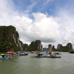
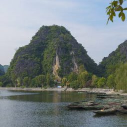
Ha Long Bay Vietnam Province: Quang Ninh N20 53 60 E107 5 60 Date of Inscription: 1994 Extension: 2000 Property : 150,000 ha Ha Long Bay Ha Long Bay, in the Gulf of Tonkin, comprises around 1,600 islands and islets, forming a spectacular seascape of limestone pillars. Due to their steep and rugged nature, most of the islands […]
Ha Long Bay
Vietnam
Province: Quang Ninh
N20 53 60 E107 5 60
Date of Inscription: 1994
Extension: 2000
Property : 150,000 ha
Ha Long Bay
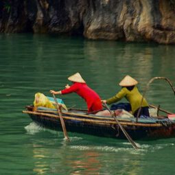
Ha Long Bay, in the Gulf of Tonkin, comprises around 1,600 islands and islets, forming a spectacular seascape of limestone pillars. Due to their steep and rugged nature, most of the islands are uninhabited and largely untouched by humans. The site’s outstanding scenic beauty is complemented by its remarkable biodiversity.
Outstanding Universal Value
Brief synthesis
Ha Long Bay, located in the Gulf of Tonkin, within Quang Ninh Province in the northeast of Vietnam, is 165 km from the capital, Ha Noi. Covering an area of 43,400 ha and including over 1,600 islands and islets, most of which are uninhabited and unaffected by humans, it forms a spectacular seascape of limestone pillars and is an ideal model of a mature karst landscape developed under a warm and wet tropical climate. The property’s exceptional scenic beauty is complemented by its great biological interest.
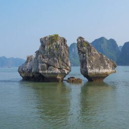
The outstanding value of the property is centered around the drowned limestone karst landforms, displaying spectacular pillars with a variety of coastal erosional features such as arches and caves, which create a majestic natural scenery. The repeated regression and transgression of the sea on the limestone karst over geological time have produced a mature landscape of clusters of conical peaks and isolated towers. These were later modified by sea invasion, adding an extra element to the process of lateral undercutting of the limestone towers and islands.
Criterion (vii): Comprising a multitude of limestone islands and islets rising from the sea in a variety of sizes and shapes, and presenting picturesque, unspoiled nature, Ha Long Bay is a spectacular seascape sculpted by natural forces. The property retains a high level of naturalness and, despite its long history of human use, is not seriously degraded. Outstanding features of the property include the magnificent towering limestone pillars and associated notches, arches, and caves, which are exceptionally well-developed and among the best examples of their type in the world.
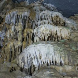
Criterion (viii): As the most extensive and best-known example of marine-invaded tower karst in the world, Ha Long Bay is one of the world’s most important areas of Fengcong (clusters of conical peaks) and Fenglin (isolated tower features) karst. Abundant lakes, occupying drowned dolines, are one of the distinctive features of the Fengcong karst, with some appearing to be tidal. Possessing a tremendous diversity of caves and other landforms derived from the unusual geomorphological process of marine-invaded tower karst, the caves fall into three main types: remnants of phreatic caves, old karstic foot caves, and marine notch caves. The property also displays the full range of karst formation processes on a very large scale and over a long geological period, offering the most complete and extensive example of its type in the world and providing a unique reservoir of data for future understanding of geoclimatic history and the nature of karst processes in a complex environment.
——————————————
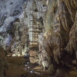
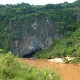
Phong Nha-Ke Bang National Park
Vietnam
Province: Quang Tri
N17 32 14 E106 9 4.5
Date of Inscription: 2003
Extension: 2015
Property : 123,326 ha
Buffer zone: 220,055 ha
Phong Nha-Ke Bang National Park
The Phong Nha-Ke Bang National Park, inscribed on the World Heritage List in 2003, covers 85,754 hectares. With this extension, the site now covers a total surface area of 126,236 hectares (a 46% increase) and shares a boundary with the Hin Namno Nature Reserve in the Lao People’s Democratic Republic. The park’s landscape is formed by limestone plateaus and tropical forests. It features great geological diversity and offers spectacular phenomena, including a large number of caves and underground rivers. The site harbours a high level of biodiversity and many endemic species. The extension ensures a more coherent ecosystem while providing additional protection to the catchment areas that are of vital importance for the integrity of limestone landscapes.
Outstanding Universal Value
Brief synthesis
Phong Nha-Ke Bang National Park is located in the middle of the Annamite Mountain Range in Quang Binh Province, Vietnam, and shares its boundary with the Hin Namno Nature Reserve in the Lao PDR to the west. The property comprises an area of 123,326 ha and contains terrestrial and aquatic habitats, primary and secondary forests, sites of natural regeneration, tropical dense forests, and savannas. It is also rich in large, often spectacular, and scientifically significant caves.
The property contains and protects over 104 km of caves and underground rivers, making it one of the most outstanding limestone karst ecosystems in the world. The karst formation has evolved since the Palaeozoic period (some 400 million years ago) and is the oldest major karst area in Asia. Subject to massive tectonic changes, the karst landscape is extremely complex, comprising a series of rock types interbedded in complex ways, with many geomorphic features. The karst landscape is not only complex but also ancient, with high geodiversity and geomorphic features of considerable significance.
The karst formation process has led to the creation of not only underground rivers but also a variety of cave types including dry caves, terraced caves, suspended caves, dendritic caves, and intersecting caves. With a length of over 44.5 km, Phong Nha Cave is the most famous of the system, with tour boats able to travel inside to a distance of 1,500 m. Son Doong Cave, first explored in 2009, is believed to contain the world’s largest cave passage in terms of diameter and continuity.
A large number of faunal and floral species occur within the property, with over 800 vertebrate species recorded, comprising 154 mammals, 117 reptiles, 58 amphibians, 314 birds, and 170 fish. The property clearly has impressive levels of biodiversity within its intact forest cover, notwithstanding gaps in knowledge about the population status of certain species.
Criterion (viii): Phong Nha-Ke Bang National Park is part of a larger dissected plateau, which encompasses the Phong Nha, Ke Bang, and Hin Namno karsts. The limestone is not continuous and demonstrates complex interbedding with shales and sandstones, leading to a particularly distinctive topography. The caves demonstrate a distinct sequence of events, resulting in multiple levels of ancient abandoned passages; evidence of major changes in the routes of underground rivers; changes in the solutional regime; deposition and later re-dissolution of giant speleothems; and unusual features such as subaerial stromatolites. On the surface, there is a striking series of natural landscapes, ranging from deeply dissected ranges and plateaux to an immense polje. There is evidence of at least one period of hydrothermal activity in the evolution of this ancient mature karst system. The Son Doong Cave, first explored in 2009, may contain the world’s largest cave passage in terms of diameter and continuity. The plateau is one of the finest and most distinctive examples of a complex karst landform in Southeast Asia, and the property is of great importance for enhancing our understanding of the geologic, geomorphic, and geochronological history of the region.
Criterion (ix): Phong Nha-Ke Bang National Park consists of a complex limestone landscape, which includes very large caves and underground rivers. The property contains karst formations that rank among the oldest and largest in Asia. It also has geological, climatic, hydrographic, and ecological conditions distinct from other limestone karst landscapes. Its cave ecosystems and habitats are unique, with high levels of endemism and remarkable adaptations displayed by cave-dependent species. The property constitutes one of the largest remaining areas of relatively intact moist forest on karst in Indochina, with forest cover estimated at 94%, of which 84% is thought to be primary forest. Furthermore, the property protects globally significant ecosystems within the priority ecoregions of the Northern Annamites Rainforests and the Annamite Range Moist Forests.
Criterion (x): The property harbors a high level of biodiversity, with over 2,700 species of vascular plants and more than 800 vertebrate species. Several globally threatened species are also present: 133 plant species and 104 vertebrate species have been reported, including large mammals such as the endangered Large-antlered Muntjac and Clouded Leopard, as well as the critically endangered Saola. The level of endemism is high, especially within the cave systems. It is estimated that more than 400 plant species endemic to Viet Nam are found within the property, along with 38 animal species endemic to the Annamite Range. Several species new to science have recently been discovered, including cave scorpions, fish, lizards, snakes, and turtles, with more species likely to be identified in the future. Importantly, four threatened primate taxa endemic to the Annamites are found within the property: the Hatinh Langur (specialized in karst forests and endemic to Viet Nam and Laos), the black form of the Hatinh Langur, sometimes considered a separate species, the Red-shanked Douc Langur, and the largest remaining population of White-cheeked Gibbon.
——————————————–
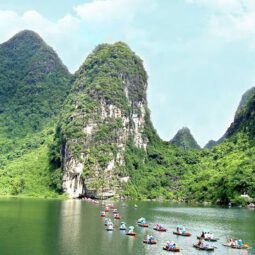
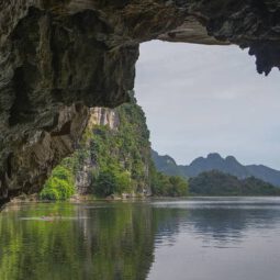
Trang An Landscape Complex
Trang An Landscape Complex
Situated near the southern margin of the Red River Delta, the Trang An Landscape Complex is a spectacular landscape of limestone karst peaks interspersed with valleys, many of them partly submerged and surrounded by steep, almost vertical cliffs. Exploration of caves at various altitudes has revealed archaeological traces of human activity over a continuous period of more than 30,000 years. These traces illustrate the occupation of the mountains by seasonal hunter-gatherers and their adaptation to major climatic and environmental changes, especially the repeated inundation of the landscape by the sea after the last ice age. The history of human occupation continues from the Neolithic and Bronze Ages into the historical era. Hoa Lu, the ancient capital of Viet Nam, was strategically established here in the 10th and 11th centuries. The property also contains temples, pagodas, paddy fields, and small villages.
Outstanding Universal Value
Brief synthesis
Located in Ninh Binh Province in northern Vietnam, near the southern margin of the Red River Delta, the Trang An Landscape Complex (Trang An) is a mixed cultural and natural property, contained mostly within three protected areas: the Hoa Lu Ancient Capital, the Trang An-Tam Coc-Bich Dong Scenic Landscape, and the Hoa Lu Special-Use Forest. The property covers 6,226 hectares within the Trang An limestone massif, and is surrounded by a buffer zone of 6,026 hectares, consisting mostly of rural land with rice paddy fields. About 14,000 residents live in the area, the majority of whom are families engaged in subsistence agriculture, though much of the property remains uninhabited and in a natural state.
Trang An is globally significant as an outstanding humid tropical tower-karst landscape in the final stages of geomorphic evolution. It is composed of a variety of classical karst cones and towers, together with a network of enclosed depressions connected by an intricate system of subterranean waterways, some of which can be navigated by small boats. The area is unique in having been invaded by the sea several times in the recent geological past, but now lies emergent on land. The blend of towering mountains draped in natural rainforest, large internal basins, and narrow cave passages where quietly flowing waters run, creates an extraordinarily beautiful and tranquil landscape.
Archaeological deposits in caves reveal a regionally significant, continuous sequence of human occupation and use spanning more than 30,000 years. There is convincing evidence of how early human groups adapted to changing landscapes in the massif, including some of the most extreme climatic and environmental changes of the planet’s recent history.
Criterion (v): Trang An is an outstanding site within Southeast Asia for demonstrating how early humans interacted with the natural landscape and adapted to major changes in climatic, geographical, and environmental conditions over more than 30,000 years. The long cultural history is closely associated with the geological evolution of the Trang An limestone massif during the late Pleistocene and early Holocene, when the inhabitants endured some of the most turbulent climatic and environmental changes in Earth’s history, including repeated submergence of the landscape due to oscillating sea levels. Within this compact landscape are numerous sites covering multiple periods and functions, representing early human settlement systems.
Criterion (vii): The exceptionally beautiful tower-karst landscape of Trang An is dominated by a spectacular array of forest-mantled limestone rock towers, rising up to 200 metres high. These are linked in places by sharp ridges enclosing deep depressions filled with waterways, interconnected by a myriad of subterranean cave passages. These features all contribute to a multi-sensory visitor experience, heightened by contrasting and ever-changing colours — the deep green of tropical rainforests, the grey of limestone rocks and cliffs, the blue-green of the waters, the brilliant blue of the sky, and the green and yellow of cultivated rice paddies. Visitors, conveyed in traditional sampans rowed by local guides, experience an intimate connection with the natural environment and a profound sense of serenity and security. The dramatic mountains, mysterious caves, and sacred places in Trang An have inspired people through countless generations.
Criterion (viii): Trang An is a superb geological property that displays, in a globally exceptional way, the final stages of tower-karst landscape evolution in a humid tropical environment. Deep dissection of an uplifted limestone massif over a period of five million years has produced a series of classical karst landforms, including cones, towers, enclosed depressions (cockpits), interior-draining valleys (poljes), foot caves, and subterranean passages decorated with speleothems. The presence of transitional forms between ‘fengcong’ karst, with ridges connecting towers, and ‘fenglin’ karst, where towers stand isolated on alluvial plains, is an extremely significant feature of the property. Trang An is an unusual autogenic karst system, fed only by rain and hydrologically isolated from rivers in the surrounding terrain. Former inundation by the sea transformed the massif into an archipelago during certain periods, though it is fully emergent on land today. Fluctuations of sea level are evidenced by an altitudinal series of erosion notches in the cliffs, along with associated caves, wave-cut platforms, beach deposits, and marine shell layers.
——————————————-
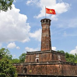
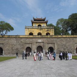
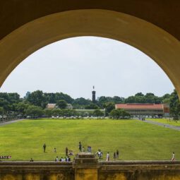
Central Sector of the Imperial Citadel of Thang Long – Hanoi
Vietnam
N21 2 15.072 E105 50 19.043
Date of Inscription: 2010
Criteria: (ii)(iii)(vi)
Property : 18.395 ha
Buffer zone: 108 ha
Central Sector of the Imperial Citadel of Thang Long – Hanoi
The Thang Long Imperial Citadel was built in the 11th century by the Ly Viet Dynasty, marking the independence of the Dai Viet. It was constructed on the remains of a Chinese fortress dating from the 7th century, on drained land reclaimed from the Red River Delta in Hanoi. It was the centre of regional political power for almost 13 centuries without interruption. The Imperial Citadel buildings and the remains in the 18 Hoang Dieu Archaeological Site reflect a unique South-East Asian culture specific to the lower Red River Valley, at the crossroads between influences coming from China in the north and the ancient Kingdom of Champa in the south.
Outstanding Universal Value
Brief summary
The Central Sector of the Imperial Citadel of Thang Long – Hanoi, located in the heart of the capital of Viet Nam, is the most important and best-preserved part of the ancient Imperial Citadel of Thang Long.
Built in the 11th century by the Ly Dynasty of Viet Nam, the Thang Long Imperial Citadel marked the independence of Dai Viet. It was constructed on the remains of a Chinese fortress dating from the 7th century, on drained land reclaimed from the Red River Delta. It served as the centre of regional political power for almost thirteen centuries without interruption.
The buildings of the Imperial Citadel and the remains in the 18 Hoang Dieu Archaeological Site reflect a unique Southeast Asian culture specific to the lower Red River Valley, at the crossroads of influences coming from China in the north and the ancient Kingdom of Champa in the south.
The Imperial Citadel of Thang Long is characterized by its remarkable longevity and continuity as a seat of power, evidenced by different archaeological layers and monuments.
Criterion (ii): The Central Sector of the Imperial Citadel of Thang Long – Hanoi bears witness to the convergence of cultural influences originating mainly from China in the north and the Kingdom of Champa in the south. It embodies a series of intercultural exchanges that shaped a distinctive and unique culture in the lower Red River Valley.
Criterion (iii): The Central Sector of the Imperial Citadel of Thang Long bears witness to the long-standing cultural tradition of the Viet people established in the Delta and the lower Red River Valley. It has remained a continuous seat of power from the 7th century up to the present day.
Criterion (vi): The Imperial Citadel of Thang Long in Hanoi, with its political function and symbolic role, is directly associated with numerous important cultural and historical events, as well as leading artistic expressions and moral, philosophical, and religious ideas. The succession of these events marks the formative and developmental process of an independent nation over more than a thousand years, encompassing the colonial period and the two contemporary wars of independence and reunification of Viet Nam.
—————————————–
Citadel of the Ho Dynasty
Vietnam
N20 4 41 E105 36 17
Date of Inscription: 2011
Criteria: (ii)(iv)
Property : 155.5 ha
Buffer zone: 5,078.5 ha
Citadel of the Ho Dynasty
The 14th-century Ho Dynasty Citadel, built according to feng shui principles, testifies to the flourishing of Neo-Confucianism in late 14th-century Vietnam and its spread to other parts of East Asia. According to these principles, it was sited in a landscape of great scenic beauty on an axis joining the Tuong Son and Don Son mountains, in a plain between the Ma and Buoi rivers. The citadel buildings represent an outstanding example of a new style of Southeast Asian imperial city.
Outstanding Universal Value
Brief synthesis
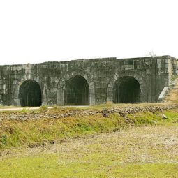
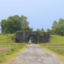
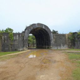
The Citadel of the Ho Dynasty, built in 1397, and composed of the Inner Citadel, La Thanh Outer Wall, and the Nam Giao Altar, covers 155.5 ha and is surrounded by a buffer zone of 5,078.5 ha. It is located in accordance with geomantic principles, in a landscape of great scenic beauty between the Ma and Buoi rivers in Vinh Loc District, Thanh Hoa Province, Vietnam.
The Inner Citadel, constructed of large limestone blocks, represents a new development in architectural technology and the adaptation of geomantic city planning in an East Asian and Southeast Asian context. It demonstrates the use of architectural elements in terms of space management and decoration, designed for a centralized imperial city to express a concept of royal power based on Confucian philosophy within a predominantly Buddhist culture.
As the capital of Viet Nam from 1398 to 1407, and later the political, economic, and cultural centre of North Central Viet Nam from the 16th to the 18th century, it bears exceptional testimony to a critical period in Vietnamese and Southeast Asian history, when traditional kingship and Buddhist values were giving way to new trends in technology, commerce, and centralized administration.
Criterion (ii): The property exhibits Chinese Confucian influence as a symbol of regal centralized power in the late 14th to early 15th centuries. It represents new developments in architectural style and technology, and, in adapting pre-existing geomantic city-planning principles within an East Asian and Southeast Asian context, makes full use of the natural surroundings and incorporates distinctly Vietnamese as well as East and Southeast Asian elements in its monuments and landscape.
Criterion (iv): The Ho Citadel is an outstanding example of an architectural ensemble in a landscape setting that illustrates the flowering of pragmatic Neo-Confucianism in late 14th-century Vietnam, at a time when it was spreading throughout East Asia to become a major philosophical influence on governance in the region. The use of large stone blocks testifies to the organizational power of the Neo-Confucian state, and the shift in the main axis distinguishes the layout of the Citadel from the Chinese norm.
————————————————–
Complex of Hue Monuments
Vietnam
Province: Hue City
N16 28 9.984 E107 34 40.008
Date of Inscription: 1993
Criteria: (iv)
Property : 315.47 ha
Buffer zone: 71.93 ha
Complex of Hue Monuments
Established as the capital of unified Viet Nam in 1802, Hue was not only the political but also the cultural and religious centre under the Nguyen dynasty until 1945. The Perfume River winds its way through the Capital, Imperial, and Forbidden Purple Cities as well as the Inner City, giving this unique feudal capital a setting of great natural beauty.
Outstanding Universal Value
Brief synthesis
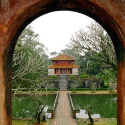
The Complex of Hue Monuments is located in and around Hue City, in the geographical centre of Vietnam, with easy access to the sea. Established as the capital of the unified Vietnam in 1802 CE, Hue was not only the political but also the cultural and religious centre under the Nguyen Dynasty — the last royal dynasty in Vietnamese history — from 1802 to 1945 CE.
The plan of the new capital was designed in accordance with ancient Oriental philosophy and respected the physical conditions of the site. The Ngu Binh Mountain (known as the Royal Screen) and the Perfume River, which runs through the city, give this unique feudal capital a setting of great natural beauty as well as define its symbolic importance. The site was chosen for a combination of natural features – hills representing a protective screen in front of the monuments or taking the role of the “blue dragon” to the left and the “white tiger” to the right – which shield the main entrance and prevent the entry of malevolent spirits. Within this landscape, the main features of the city are laid out.
The structures of the Complex of Hue Monuments are carefully placed within the natural setting of the site and aligned cosmologically with the Five Cardinal Points (center, west, east, north, south), the Five Elements (earth, metal, wood, water, fire), and the Five Colors (yellow, white, blue, black, red).
The central structure is the Hue Citadel area, which was the administrative centre of southern Viet Nam during the 17th and 18th centuries CE. Within the Hue Citadel were located not only the administrative and military functions of the Empire, but also the Imperial Residence, the Hoang Thanh (Imperial City), the Tu Cam Thanh (Forbidden Purple City), and related royal palaces.
Tran Binh Dai, an additional defensive work in the north-east corner of the Capital City, was designed to control movement along the river. Another fortress, Tran Hai Thanh, was constructed a little later to protect the capital against assault from the sea.
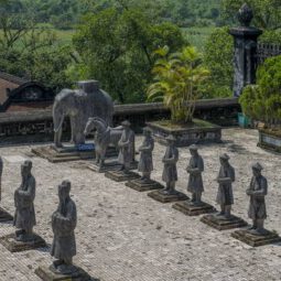
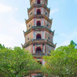
Outside the Capital City, there are several associated monuments of importance. In the outlying areas were located important ritual sites related to the spiritual life of the dynasty, such as the Van Mieu (Temple of Literature), the Dan Nam Giao (Esplanade of Sacrifice to Heaven and Earth), the Ho Quyen (Royal Arena), the Den Voi Re (Temple of the Roaring Elephant), and the Chua Thien Mu (Celestial Lady Pagoda). Further upstream, arranged along the Perfume River, were the tombs of the dynasty’s emperors.
The Complex of Hue Monuments is a remarkable example of the planning and construction of a complete defended capital city in a relatively short period in the early years of the 19th century CE. The integrity of the town layout and building design make it an exceptional specimen of late feudal urban planning in East Asia.
The Complex of Hue Monuments is a remarkable example of the planning and construction of a complete defended capital city in a relatively short period in the early years of the 19th century CE. The integrity of the town layout and building design make it an exceptional specimen of late feudal urban planning in East Asia.
Criterion (iv): The Complex of Hue Monuments is an outstanding example of an Eastern feudal capital.
——————————————
Hoi An Ancient Town
Vietnam
Hoi An Ward, Da Nang City
N15 52 60 E108 19 60
Date of Inscription: 1999
Criteria: (ii)(v)
Property : 30 ha
Buffer zone: 280 ha
Hoi An Ancient Town
Hoi An Ancient Town is an exceptionally well-preserved example of a Southeast Asian trading port dating from the 15th to the 19th century. Its buildings and street plan reflect both indigenous and foreign influences that have combined to create this unique heritage site.

Outstanding Universal Value
Brief synthesis
Hoi An Ancient Town is located in central Vietnam, Da Nang City, on the north bank near the mouth of the Thu Bon River. The inscribed property covers 30 ha and has a buffer zone of 280 ha. It is an exceptionally well-preserved example of a small-scale trading port active from the 15th to the 19th centuries, which traded extensively with countries of Southeast and East Asia as well as with the rest of the world. Its decline in the late 19th century ensured that it has retained its traditional urban fabric to a remarkable degree.
The town reflects a fusion of indigenous and foreign cultures (principally Chinese and Japanese, with later European influences) that combined to create this unique cultural heritage.
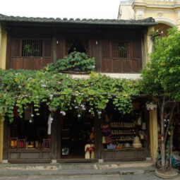
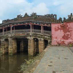
The town comprises a well-preserved complex of 1,107 timber-framed buildings with brick or wooden walls. These include architectural monuments, commercial and domestic vernacular structures—most notably an open market, a ferry quay, and religious buildings such as pagodas and family cult houses. The houses are roofed with tiles, and their wooden components are intricately carved with traditional motifs. They are arranged side by side in tight, unbroken rows along narrow pedestrian streets. There is also a fine wooden Japanese bridge with a pagoda built upon it, dating from the 18th century.
The original street plan, which developed as the town grew into a trading port, still remains intact. It comprises a grid of streets with one axis parallel to the river and the other set at right angles to it. Typically, the buildings front the streets for convenient customer access, while their backs open to the river, allowing easy loading and unloading of goods from boats.
The surviving wooden structures and street plan are original and intact, and together present a traditional townscape of the 17th and 18th centuries, the survival of which is unique in the region. To this day, the town continues to be inhabited and functions as a trading port and centre of commerce. The living heritage reflecting the diverse communities of indigenous inhabitants in the town, as well as foreigners, has also been preserved and continues to be passed on. Hoi An Ancient Town remains an exceptionally well-preserved example of a Southeast Asian port.
Criterion (ii): Hoi An is an outstanding material manifestation of the fusion of cultures over time in an international commercial port.
Criterion (v): Hoi An is an exceptionally well-preserved example of a traditional Asian trading port.
——————————————–
My Son Sanctuary
Vietnam
Thu Bon Commune, Da Nang City
N15 46 25.835 E108 6 33.008
Date of Inscription: 1999
Criteria: (ii)(iii)
Property : 142 ha
Buffer zone: 920 ha
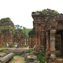
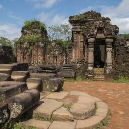
My Son Sanctuary
Between the 4th and 13th centuries, a unique culture that owed its spiritual origins to Indian Hinduism developed along the coast of what is now Vietnam. This is graphically illustrated by the remains of a series of impressive tower-temples located on a dramatic site that served as the religious and political capital of the Champa Kingdom for most of its existence.
Outstanding Universal Value
Brief synthesis
During the 4th to 13th centuries, there was a unique culture on the coast of contemporary Vietnam, owing its spiritual origins to Hinduism from India. This is graphically illustrated by the remains of a series of impressive tower temples, in a dramatic site that was the religious and political capital of the Champa Kingdom for most of its existence.
My Son Sanctuary dates from the 4th to the 13th centuries CE. The property is located in the mountainous border area of Duy Xuyen District, Quang Nam Province (currently Da Nang City), in central Vietnam. It is situated within an elevated geological basin surrounded by a ring of mountains, which provides the watershed for the sacred Thu Bon River. The source of the Thu Bon River is here, and it flows past the monuments, out of the basin, and through the historic heartland of the Champa Kingdom, draining into the South China Sea at its mouth near the ancient port city of Hoi An. The location gives the site its strategic significance, as it is also easily defensible.
The tower temples were constructed over ten centuries of continuous development in what was the heart of the ancestral homeland of the ruling Dua Clan, which unified the Cham clans and established the kingdom of Champapura (Sanskrit for “City of the Cham people”) in 192 CE. During the 4th to 13th centuries CE, this unique culture on the coast of contemporary Vietnam owed its spiritual origins to Hinduism from the Indian subcontinent. Under this influence, many temples were built to the Hindu divinities such as Krishna and Vishnu, but above all Shiva. Although Mahayana Buddhism penetrated Cham culture, probably from the 4th century CE, and became strongly established in the north of the kingdom, Shaivite Hinduism remained the established state religion.
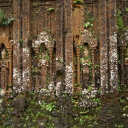
The monuments of the My Son Sanctuary are the most important constructions of the Champa civilization. The tower temples have a variety of architectural designs symbolizing the greatness and purity of Mount Meru, the mythical sacred mountain, home of the Hindu gods at the center of the universe, now symbolically reproduced on Earth in the mountainous homeland of the Cham people. They are constructed of fired brick with stone pillars and decorated with sandstone bas-reliefs depicting scenes from Hindu mythology. Their technological sophistication is evidence of Cham engineering skills, while the elaborate iconography and symbolism of the tower temples provide insight into the content and evolution of Cham religious and political thought.
The My Son Sanctuary is a remarkable architectural ensemble that developed over a period of ten centuries. It presents a vivid picture of spiritual and political life in an important phase of the history of Southeast Asia.
The monuments are unique and without equal in Southeast Asia.
Criterion (ii): The My Son Sanctuary is an exceptional example of cultural interchange, with an indigenous society adapting to external cultural influences, notably the Hindu art and architecture of the Indian subcontinent.
Criterion (iii): The Champa Kingdom was an important phenomenon in the political and cultural history of Southeast Asia, vividly illustrated by the ruins of My Son.