World heritage in Laos
Megalithic Jar Sites in Xiengkhuang – Plain of Jars Lao People’s Democratic Republic N19 25 51.8 E103 9 8 Date of Inscription: 2019 Criteria: (iii) Property : 174.56 ha Buffer zone: 1,012.94 ha Ref: 1587 Megalithic Jar Sites in Xiengkhuang – Plain of Jars The Plain of Jars, located on a plateau in central Laos, gets its name from more […]
Megalithic Jar Sites in Xiengkhuang – Plain of Jars
Lao People’s Democratic Republic
- N19 25 51.8 E103 9 8
- Date of Inscription: 2019
- Criteria: (iii)
- Property : 174.56 ha
- Buffer zone: 1,012.94 ha
- Ref: 1587
Megalithic Jar Sites in Xiengkhuang – Plain of Jars
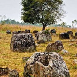
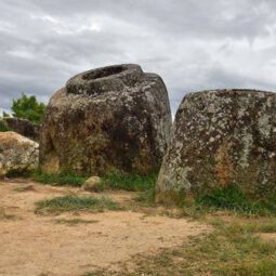
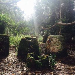
The Plain of Jars, located on a plateau in central Laos, gets its name from more than 2,100 tubular-shaped megalithic stone jars used for funerary practices in the Iron Age. This serial property of 15 components contains large carved stone jars, stone discs, secondary burials, tombstones, quarries and funerary objects dating from 500 BCE to 500 CE. The jars and associated elements are the most prominent evidence of the Iron Age civilization that made and used them until it disappeared, around 500 CE.
Outstanding Universal Value
Brief synthesis
More than 2100 tubular-shaped megalithic stone jars used for funerary practices in the Iron Age give the Plain of Jars its name. This serial property of 15 components contains 1325 of these large carved stone jars, stone discs (possibly lids for the jars), secondary burials, grave markers, quarries, manufacturing sites, grave goods and other features. Located on hill slopes and spurs surrounding the central plateau, the jars are large, well-crafted, and required technological skill to produce and move from the quarry locations to the funerary sites. The jars and associated elements are the most prominent evidence of the Iron Age civilisation that made and used them, about which little is known. The sites are dated from between 500 BCE and 500 CE (and possibly up to as late as 800 CE). The jars and associated archaeological features provide evidence of these ancient cultural practices, including associated social hierarchies. The Plain of Jars is located at an historical crossroads between two major cultural systems of Iron Age southeast Asia – the Mun-Mekong system and the Red River/Gulf of Tonkin system. Because the area is one that facilitated movement through the region, enabling trade and cultural exchange, the distribution of the jars sites is thought to be associated with overland routes.
Criterion (iii): The Plain of Jars exhibits an exceptional testimony to the civilisation that made and used the jars for their funerary practices over a period from approximately 500 BCE to sometime after 500 CE. The size of the megalithic jars, and their large number and wide distribution within the Province of Xiengkhuang is remarkable, and the serial property of 15 components contains a range of sites that can attest to the quarrying, manufacturing, transportation and use of the funerary jars over this lengthy period of southeast Asian cultural histories.
Integrity
The integrity of the serial property is based on the material evidence contained in the 15 components, the intactness of the individual components and the series as a whole, and the relatively stable state of conservation of the attributes. There are impacts on the visual integrity of some components, such as the construction of new houses and Buddhist temple outside the buffer zone for Site 1; poorly sited roads/tracks within several components; and conservation problems and intrusive constructions within Site 3. Some attributes have been damaged in the past by bombing and other effects of war, and by cattle grazing.
Authenticity
The authenticity of the serial property is based on the form, design, materials and locations of the megalithic jars and other attributes such as lids, secondary burials and archaeological deposits. For the most part, the materials are original, located in their original locations, with relatively little disturbance to the archaeological deposits. While past factors have damaged the jars and their settings, their abundance, antiquity and condition support the authenticity of the serial property.
Management and protection requirements
The serial property is protected under the Law on National Heritage 2013, supported by the Decree of the President of the Lao People’s Democratic Republic on the Preservation of Cultural, Historical and Natural Heritage 1997, and the Provincial Governor’s Decree concerning the Management and Conservation of the Plain of Jars World Heritage Sites No. 996. In addition, Decree No. 870 concerning Establishment and Operation of Plain of Jars Heritage Technical Division sets up the structure, duties of the newly-established site management office. Provincial governor’s Decree No. 995 provides a mechanism for funding site conservation through revenue sharing from tourism. Implementation of the mechanisms of protection occurs at the national, provincial, district and village levels. Coordination is provided by the National Committee for World Heritage and the Xiengkhuang Heritage Steering Committee. A 5-year action plan of specific projects has been developed, including an archaeological research plan, as well as resources for fencing, basic visitor facilities, road improvements, implementation of the national heritage law, and production of interpretive materials. The day-to-day management of most components is provided by nearby villages based on contracts established with the Provincial Government; and a formula for sharing the income from ticket sales with local communities is in place.
The main factors affecting this property are processes of natural deterioration and future development pressures. The State Party has recently achieved the clearance of UXO from the components, commendably removing a challenging barrier to access, research and safety.
The management system requires further development, including the establishment of a management plan and a conservation plan to ensure coordination and consistent conservation approaches, and to pursue needed longer-term strategic improvements. A number of aspects of the management system are yet to be fully implemented, such as the arrangements for Heritage Impact Assessment. Interpretation and provision of information about the sites to visitors are modest and should be enhanced in the longer term, particularly in light of continuing archaeological research and sustainable tourism initiatives for the Province.
——————————-
Town of Luang Prabang
Lao People’s Democratic Republic
- Province of Luang Prabang
- N19 53 20.004 E102 7 59.988
- Date of Inscription: 1995
- Minor boundary modification inscribed year: 2013
- Criteria: (ii)(iv)(v)
- Property : 820 ha
- Buffer zone: 12,560 ha
- Ref: 479bis
Town of Luang Prabang
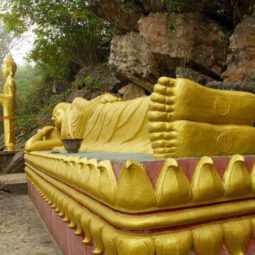
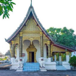
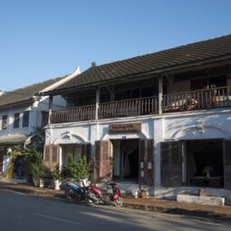
Luang Prabang is an outstanding example of the fusion of traditional architecture and Lao urban structures with those built by the European colonial authorities in the 19th and 20th centuries. Its unique, remarkably well-preserved townscape illustrates a key stage in the blending of these two distinct cultural traditions.
Outstanding Universal Value
Brief synthesis
Luang Prabang is located in northern Laos at the heart of a mountainous region. The town is built on a peninsula formed by the Mekong and the Nam Khan River. Mountain ranges (in particular the PhouThao and PhouNang mountains) encircle the city in lush greenery.
Many legends are associated with the creation of the city, including one that recounts that Buddha would have smiled when he rested there during his travels, prophesying that it would one day be the site of a rich and powerful city. Known as Muang Sua, then Xieng Thong, from the 14th to the 16th century the town became the capital of the powerful kingdom of Lane Xang (Kingdom of a Million Elephants), whose wealth and influence were related to its strategic location on the Silk Route. The city was also the centre of Buddhism in the region. Luang Prabang takes its name from a statue of Buddha, the Prabang, offered by Cambodia.
After the establishment of the French Protectorate in 1893, following a period of turmoil during which the country was divided into three independent kingdoms, Luang Prabang once again became the royal and religious capital during the reign of King Sisavang Vong. It played this role until Vientiane became the administrative capital in 1946.
Luang Prabang is exceptional for both its rich architectural and artistic heritage that reflects the fusion of Lao traditional urban architecture with that of the colonial era. Its remarkably well-preserved townscape reflects the alliance of these two distinct cultural traditions.
The political and religious centre of Luang Prabang is the peninsula, with its royal and noble residences and religious foundations. The traditional urban fabric of the old villages, each with its temple, was preserved by later constructions. The colonial urban morphology, including the network of streets, overlapped harmoniously with the previous model. Formerly the town limits were defined by defensive walls.
The richness of Luang Prabang architecture reflects the mix of styles and materials. The majority of the buildings are, following tradition, wooden structures. Only the temples are in stone, whereas one- or two-storey brick houses characterize the colonial element of the town. The many pagodas or “Vat” in Luang Prabang, which are among the most sophisticated Buddhist temples in Southeast Asia, are richly decorated (sculptures, engravings, paintings, gilding and furniture pieces). Wat Xieng Thong, which dates from the 16th century, comprises an ensemble of the most complex structures of all the pagodas of the town. It is remarkable both from the archaeological point of view, and from the Lao iconographic and aesthetic viewpoint.
Many traditional Lao houses remain; they are built of wood using traditional techniques and materials introduced in the colonial period, such as plaited bamboo panels coated with wattle and daub. Brick colonial buildings, often with balconies and other decorative features in wood, line the main street and the Mekong.
The built heritage of Luang Prabang is in perfect harmony in the natural environment. The sacred Mount Phousi stands at the heart of the historic town built on a peninsula delimited by the Mekong and the Nam Khan, domain of the mythical naga. Ceremonies to appease the nagas and other evil spirits, and Buddhist religious practices (Prabang procession, the monks’ morning quest) perpetuate the sanctity of the place. Natural spaces located in the heart of the city and along the riverbanks, and wetlands (a complex network of ponds used for fish farming and vegetable growing) complement this preserved natural environment.
Criterion (ii): Luang Prabang reflects the exceptional fusion of Lao traditional architecture and 19th and 20th century European colonial style buildings.
Criterion (iv): Luang Prabang is an outstanding example of an architectural ensemble built over the centuries combining sophisticated architecture of religious buildings, vernacular constructions and colonial buildings.
Criterion (v): The unique townscape of Luang Prabang is remarkably well preserved, illustrating a key stage in the blending of two distinct cultural traditions.
Integrity
The integrity of the inscribed site is linked to an architectural and cultural heritage set in a natural landscape that reflects its Outstanding Universal Value. All of the significant elements, especially the urban fabric and major monuments (temples, public buildings, traditional houses), have been preserved.
However, there are some threats to the site due to the rapid development of the town and strong economic pressures, many of which are related to tourism (transformation of use of buildings, departure of residents, illegal construction).
Authenticity
The landscapes and urban fabric retain a high degree of authenticity, and the site is not disturbed by any major construction.
The religious buildings are regularly maintained; monks teach young monks restoration techniques for their heritage. Moreover, the Buddhist cult and the cultural traditions related to it (rites and ceremonies) are still alive and practiced diligently.
However, the degree of the authenticity of materials and construction techniques of many houses is low, since, for a long period, unsuitable modern techniques and materials (concrete, in particular) have often been used to replace traditional materials.
Protection and management requirements
The protection of the monuments and religious buildings of Luang Prabang is ensured by Decree No. 1375: 1978 of the Ministry of National Education and Sports, under the responsibility of the national and provincial administrations of the Lao Buddhist Federation. Decree No. 139, 1990, of the Ministry of Information and Culture assigns responsibility for heritage protection to this Ministry (at national level), to the Information and Culture Service (regional level) and to the district (local level). Article 16 of the Law on Environmental Protection No 09/NA, 1999, focuses on the historical, cultural and natural heritage; Article 7 deals with the obligation to conduct a socio-environmental impact analysis before undertaking any development and infrastructure project. Law No. 08 / NA on the national heritage, enacted in 2005, reinforces this legal arsenal.
The authorities have developed the tools necessary to manage the property: Law on urban heritage protection, establishment of decentralized cooperation with the French town of Chinon, creation of a Luang Prabang World Heritage Department and establishment of National and Local Heritage Committees.
The Safeguarding and Enhancement Plan (SEP) of the city consists both of a regulatory component having the force of law and a more adaptable component regarding recommendations to support projects while leaving some flexibility The religious authorities are particularly sensitive to the value of their heritage, with the support of the population. To counter the negative effects of rapid urban development, the regulations of the SEP include measures that the Department of Heritage must apply under the responsibility of the Local Heritage Committee and the National Committee.
To respond to the new challenges (sustainable tourism, preservation of landscapes and surrounding agricultural areas), a wide buffer zone of 12,500 ha has been defined in the context of the revision of the Urban Plan that was approved by decree of the Prime Minister in February 2012. Large projects (new town, big hotels) are deferred until their impact can be assessed in regard to the Plan. In addition, public buildings (primary school, Fine Arts School) will not be conceded to the private sector, but they will be restored and will retain their cultural vocation. The Heritage House was restructured to become the Heritage Department in 2009. The new Heritage Department ensures strict application of the SEP and Urban Plan. Its mission is also to coordinate the actions of the Local Committee, raise awareness of the universal values of the heritage of Luang Prabang and advise those involved in development and infrastructure projects. Measures related to the use of traditional materials and techniques (wood, brick, tile and local ceramic) will be strengthened in order to preserve the integrity of the built heritage and local building traditions.
——————————
Vat Phou and Associated Ancient Settlements within the Champasak Cultural Landscape
Lao People’s Democratic Republic
- Champasak Province
- N14 50 54 E105 49 20
- Date of Inscription: 2001
- Criteria: (iii)(iv)(vi)
- Property : 39,000 ha
- Ref: 481
Vat Phou and Associated Ancient Settlements within the Champasak Cultural Landscape
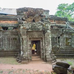
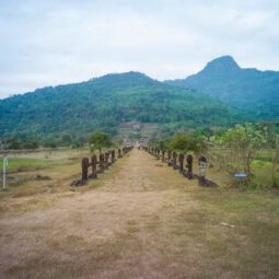
The Champasak cultural landscape, including the Vat Phou Temple complex, is a remarkably well-preserved planned landscape more than 1,000 years old. It was shaped to express the Hindu vision of the relationship between nature and humanity, using an axis from mountain top to river bank to lay out a geometric pattern of temples, shrines and waterworks extending over some 10 km. Two planned cities on the banks of the Mekong River are also part of the site, as well as Phou Kao mountain. The whole represents a development ranging from the 5th to 15th centuries, mainly associated with the Khmer Empire.
Justification for Inscription
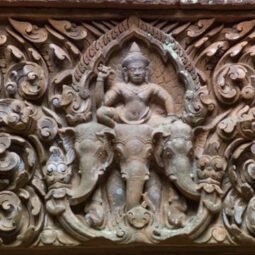
Criterion iii The Temple Complex of Vat Phou bears exceptional testimony to the cultures of south-east Asia, and in particular to the Khmer Empire which dominated the region in the 10th–14th centuries. Criterion iv The Vat Phou complex is an outstanding example of the integration of symbolic landscape of great spiritual significance to its natural surroundings. Criterion vi Contrived to express the Hindu version of the relationship between nature and humanity, Vat Phou exhibits a remarkable complex of monuments and other structures over an extensive area between river and mountain, some of outstanding architecture, many containing great works of art, and all expressing intense religious conviction and commitment.


