Getting to Myanmar
By Flight
There are very few international flights to Myanmar. Bangkok, Singapore, and Kuala Lumpur are the best connection from around the world to get into Myanmaryou’re your tour begins in China, you can catch a weekly flight from Kunming to Yangon, whose international airport is the main entry of the country, while a Thursday flight from Chiang Mai to Mandalay is an exception.
By Land
There are three Thai and Myanmar border crossing for visitors to reach Myanmar: Mai Sai, Mai Sot, and Ranong. It’s possible to get a visa-free entry, but extra paperwork and an entry fee around 10 dollars are needed.
Getting Around Myanmar
By Flight
Since the road of Myanmar is in poor condition, flying is the most comfortable choice for travelers. When booking domestic air travel, be patient to the time it needs to take and confirm your flight 24 hours ahead.
By Train
It’s always not suggested take train to travel in Myanmar for the frequent delays, slow speed, poor service and terrible sanitary condition of the toilets. Oftentimes foreign visitors are even overcharged.
By Car
A hired private van is your best transportation when you want to tour independently. Consider using the professional driving team at Indochina Odyssey Tours, which hires only licensed drivers who are all expected to be well dressed and non-smoking. Your vehicle in each destination is air conditioned, insured, clean, and regularly maintained.
By Pickup Truck
It’s the Myanmar-style tuk-tuk that is usually converted into a canvas with benches on the rear. Since taxi could be expensive to hail, the inexpensive fare of pickup attracts mainly the locals and monks for short distance commute. For those who go off the beaten track, pickup is a nice choice to experience the real lifestyle of Myanmar people.
Road
otal: 27,000 km (16,777 mi) paved: 3,200 km (1,988 mi) unpaved: 23,800 km (14,789 mi) (2006)
The main highways are as follows:
1 – Runs from Yangon to Mandalay, passing through Bago, Taungoo, Pyinmana and Meiktila.
2 – Runs from Yangon to Mandalay, passing through Pyay, Magwe, Kyaukpadaung and Myingyan.
3 – Runs from Mandalay to Muse, on the border with China, passing through Lashio.
4 – Runs from Meiktila to Tachileik, on the border with Thailand, passing through Taunggyi and Kengtung.
5 – Runs from Taungoo to Hopong, passing through Loikaw.
6 – Runs from Yangon to Pathein.
7 – Runs from Mandalay to Moreh, on the border with India, passing through Shwebo and Kale.
8 – Runs from Hpagyargyi to Myeik, passing through Moulmein, Ye and Dawei.
31 – Runs from Mandalay to Myitkyina, passing through Mogok and Bhamo.
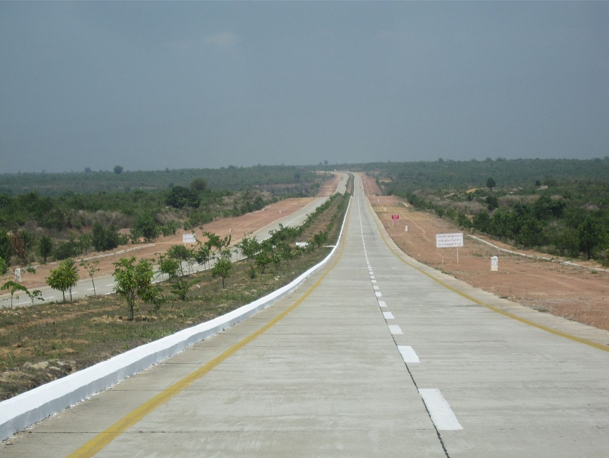
There is one expressway in the country, which features double carriageway and four lanes on its entire length:
- Yangon-Mandalay Expressway– Runs from Yangon to Mandalay, by-passing Bago, Taungoo, Naypyidaw and Meiktila. Length: 587 km.
The other Highways are as follows:
- Wonnral Road– Runs from Naungte to Retphaw, by- passing Hlagazaing, Myohaung, Duk Daw Nain, Kale, Kayin State, Tagondaing, Tamoowoug, Taungdi, Kyongawon, Phabya, Paya and Ta Nyin. Length: 55 km.
In 2017, Yangon launched a bus network system that would reduce traffic and commute time of some two million commuters in the city.
Rail
Rail transport in Myanmar consists of a 10,296.01 km (6,398 mi) railway network with 1225 stations.. The network, generally spanning north to south with branch lines to the east and west, is the second largest in Southeast Asia, and includes the Yangon Circular Railway which serves as a commuter railway for Yangon, the principal commercial city in Myanmar. The quality of the railway infrastructure is generally poor. The tracks are in poor condition, and are not passable during the monsoon season. The speed of freight trains is heavily restricted on all existing links as a consequence of poor track and bridge conditions. The maximum speed for freight trains has been quoted as 24 km/h (15 mph), suggesting that commercial speeds on this section could be as low as 12–14 km/h (7.5–8.7 mph).
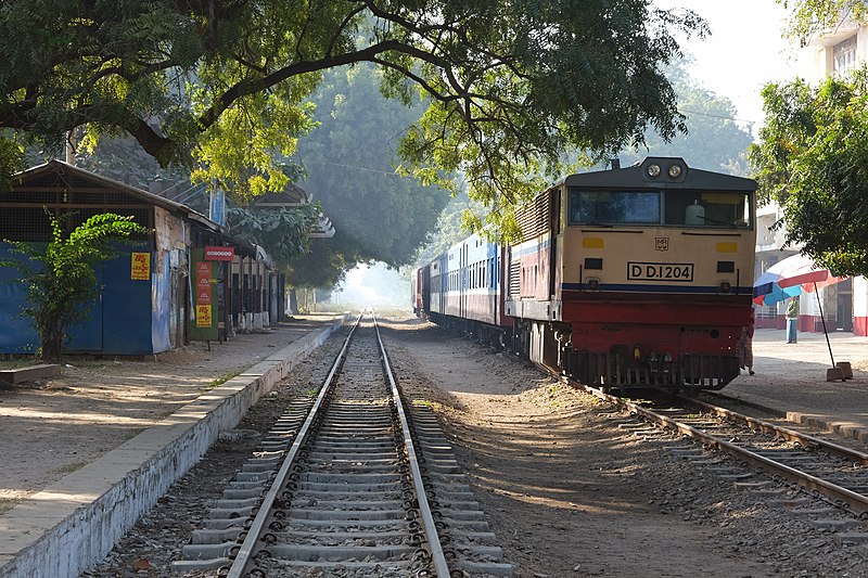
The network is run by Myanma Railways ; also spelled Myanmar Railways; formerly Burma Railways), a state-owned railway company under the Ministry of Rail Transportation. In the 2013-14 fiscal year, Myanmar Railways carried about 60 million passengers (35 million in the circular railway and 25 million inter-city travelers) and 2.5 million metric tons of freight. Its rolling stock consisted of 384 locomotives, 1,600 passenger railcars, and 3,600 freight wagons.
The network has steadily increased in size over the last two decades, from nearly 5,500 kilometres (3,400 mi) in 1988 to 10,296.01 kilometres (6,397.64 mi) in 2010. Myanmar Railways is currently undertaking an ambitious expansion program that will add another 3,645 km (2,265 mi) to its network, making it spread in to 13,941 km (8,663 mi) including extensions to Myeik in the south, Kyaingtong in the east, Sittwe in the west.
Water
12,800 km (7,954 mi); 3,200 km (1,988 mi) navigable by large commercial vessels. (2008)
Belmond Ltd operates its business in Ayeyarwady River by the name Road to Mandalay River Cruise. Irrawaddy Flotilla Company was also in service along the Ayeyarwady River in the 20th century, until 1942, when the fleet was destroyed to prevent invading Japanese forces from making use of it. The IFC has since been revived as Pandaw, named for a salvaged original IFC ship, and is now one of the leading river cruise companies in the country.
Merchant marine
total: 24 ships (with a volume of 1,000 gross tonnage (GT) or over) totalling 472,284 GT/716,533 tonnes deadweight (DWT) Ships by type: bulk carrier 1, cargo ship 17, passenger ship 2, passenger/cargo 3, specialised tanker 1 (2008) note: a flag of convenience registry; includes ships of 3 countries: Cyprus 1, Germany 1, Japan 1
Ports and harbours
Sea
River
Air
Airports
In July 2010, the country had 69 airports. Only 11 of them had runways over 3250 meters. Of the 11, only Yangon International and Mandalay International had adequate facilities to handle larger jets. total: 69 over 3,047 m: 11 1524 to 3,047 m: 27 Under 1524 m: 31
This is a list of airports in Burma (Myanmar), grouped by type and sorted by location.
Burma, officially the Union of Myanmar (now The Republic of the Union of Myanmar), has 25 operating airports with commercial flights. The country is bordered by People's Republic of China to the northeast, Laos to the east, Thailand to the southeast, Bangladesh to the west, India to the northwest, the Bay of Bengal to the southwest, and the Andaman Sea to the south. The country is divided into 14 administrative subdivisions, which include 7 states (pyi-ne) and 7 divisions (tyne). Its capital is Naypyitaw (Nay Pyi Taw) and its largest city (and prior capital) is Yangon.
Airport name | ||||
VYMD | MDL | |||
Yangon (Rangoon) | VYYY | RGN | ||
Naypyidaw (Naypyitaw) | VYNT | NYT | Nay Pyi Taw International Airport (Ela Airport) | |
Bago (Bago) | Hanthawaddy International Airport (Under Construction) | |||
VYAS | ||||
VYAN | VBA | |||
VYBG | NYU | |||
Bhamo (Banmaw) | VYBM | BMO | Bhamo Airport (Banmaw Airport) | |
Nogmung (Nogmung) | VYNM | N0M | Nogmung Airport (Nogmung Airport) | |
Bokpyin (Bokepyin) | VYBP | |||
Coco Islands (Great Coco Island) | VYCI | |||
Dawei (Tavoy) | VYDW | TVY | ||
VYGG | GAW | |||
VYGW | GWA | |||
VYHH | HEH | |||
Homalin (Hommalin) | VYHL | HOX | Homalin Airport (Hommalin Airport) | |
Hpa-An (Pa-An) | VYPA | PAA | ||
Hpapun (Papun) | VYPP | PPU | ||
Kalaymyo (Kalemyo) | VYKL | KMV | ||
Kawthaung (Kawthoung) | VYKT | KAW | ||
Kengtung (Kengtong, Kyaingtong) | VYKG | KET | ||
VYKI | KHM | |||
Kyaukpyu (Kyauk Pyu) | VYKP | KYP | ||
Kyauktu (Kyaukhtu) | VYKU | KYT | ||
Kyauktu (Kyaukhtu) | VYXG | |||
VYLY | ||||
VYLS | LSH | |||
VYLK | LIW | |||
VYMW | MWQ | |||
VYMN | MGU | |||
VYCZ | VBC | |||
Mawlamyine (Mawlamyaing) | VYMM | MNU | Mawlamyaing Airport (Mawlamyine Airport) | |
VYMO | MOE | |||
Mong Ton (Mong-Tong) | VYMT | MGK | ||
Mong Hsat (Monghsat) | VYMS | MOG | Monghsat Airport (Mong Hsat Airport) | |
Monywa (Monywar) | VYMY | NYW | Monywa Airport (Monywar Airport) | |
Myeik (Mergui) | VYME | MGZ | ||
VYMK | MYT | |||
VYNS | NMS | |||
VYNT | NMT | |||
VYPU | PKK | |||
Pathein (Bassein) | VYPN | BSX | ||
VYPK | PAU | |||
VYPT | PBU | |||
Pyay (Prome) | VYPY | PRU | ||
Sittwe (Akyab) | VYSW | AKY | ||
Tachileik (Tachilek) | VYTL | THL | ||
Thandwe (Sandoway) | VYTD | SNW | ||
VYHN | TIO | |||
VYYE | XYE |